Ocean Shores Police Department Officer Clint Potter convinced his city to buy drones for water rescue.

Jul 09 2019
Public Safety

Drones Keep an Eye on People and Property to Aid First Responders

State and local governments increasingly turn to drones to provide surveillance in places that are hard to reach.

During the summer, tourists and locals pack the 6-mile sandy beach at Ocean Shores, Wash., to relax, sunbathe and dip into the Pacific Ocean. But this year, Frisbees, beach balls and kites aren’t the only things going airborne. Add drones to the mix — not for fun, but for saving lives.

The Ocean Shores Police Department recently purchased a dozen DJI Phantom 4 Pro drones for public safety use, including water rescues at the beach. The city’s police officers learned to fly the drones this spring and are now ready to deploy them during the busy summer beach season.

If swimmers get swept away by a powerful riptide, officers responding to 911 calls can launch drones and, through high-definition cameras, locate the distressed swimmers to lower life jackets to them.

“If we save one life, it is worth the cost of the drones,” says Officer Clint Potter, who developed the drone program and trained his fellow officers and police chief to pilot them.

Cities, counties and state governments turn to drones to help fight crime, combat fires and assist in rescue efforts. When emergencies happen, the ability to fly camera-toting drones several hundred feet above a scene improves situational awareness, helps find missing people or suspects and allows local public works or state transportation officials to survey damage to roads and other infrastructure in the aftermath of natural disasters.

Source: Center for the Study of the Drone, “Public Safety Drones: An Update,” May 28, 2018

By 2018, at least 910 U.S. sheriff’s offices, police and fire departments, and emergency services agencies had purchased drones, an 82 percent increase from the previous year, according to a study by the Center for the Study of the Drone at Bard College.

The most common uses of drones are for search and rescue, emergency response, crime scene and accident scene investigations, and tactical situations, where an aerial perspective provides valuable information, says Dan Gettinger, the center’s co-director.

“We are still in the early days of adoption, but there is a growing pace of adoption by public agencies nationwide,” he says.

VIDEO: See how the police department in Opelika, Ala., is using tech to back up video from body cameras and dash cams wirelessly and make it available upon demand.

Police Departments Can Fly Drones for Search and Rescue

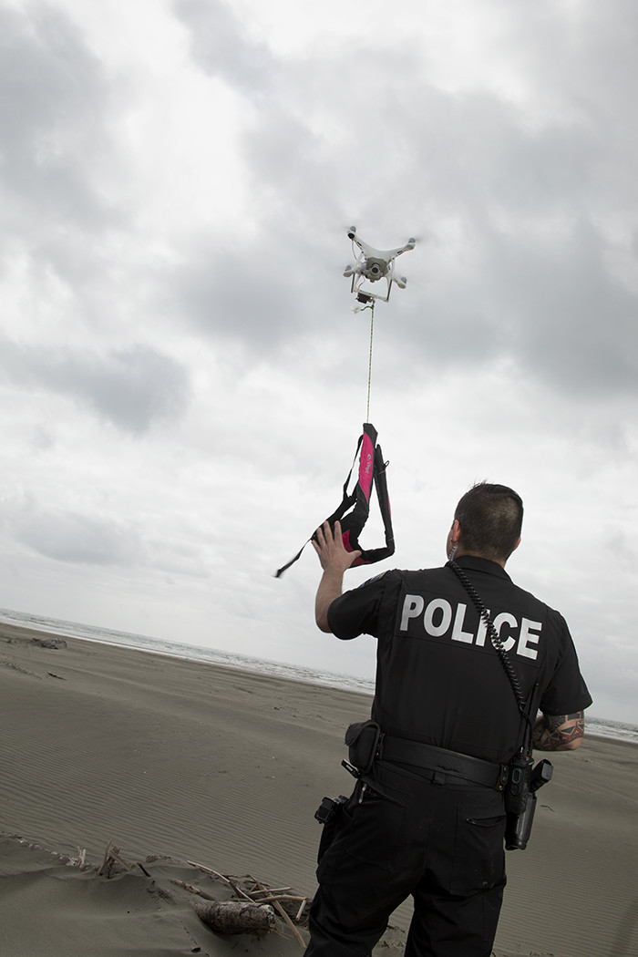
The city of Ocean Shores, which gets a dozen or more 911 calls for water rescues per year, does not allow first responders to swim into the ocean, so the new drones are an important new lifesaving tool, Potter says.

The city’s police and fire departments previously had a surf rescue team that used personal watercrafts, but it was disbanded in 2013 because of budget cuts. Since then, first responders could only respond to water emergencies in two ways: Use a line gun and shoot a life jacket to swimmers, or call the Coast Guard and wait for them to respond with a boat and helicopter, which could take 20 to 30 minutes.

“That’s a long time to be in cold water, and most people don’t survive that long,” Potter says.

Now, using drones, the city’s first responders can be more proactive. Minutes and seconds count when people are in danger of drowning, so drones can make a big difference, Potter says.

This summer, when a rescue call comes in and if the distressed swimmer is not visible from shore, the first arriving officer will launch a drone equipped with a camera to search for and locate the swimmer. The DJI controller, used to steer the drone, has an ultrabright 5.5-inch screen that gives the pilot a bird’s-eye view of the ocean.

Officer Clint Potter pilots a DJI drone in a test of its search and rescue capabilities in Ocean Shores, Wash.

Officer Clint Potter pilots a DJI drone in a test of its search and rescue capabilities in Ocean Shores, Wash.

The next officer to arrive will launch a second drone and drop a lightweight pink vest to the swimmer. The vest has a long rope attached, so if the swimmer is within 500 feet from shore, officers can pull the person back to safety. If the swimmer is too far out, a Coast Guard boat will fetch the swimmer.

“If we can’t pull them back in, then at least they can hold onto a bright pink floatie until the Coast Guard can pick them up,” says Potter, who became a Federal Aviation Administration-certified drone pilot last summer.

Potter perfected the rescue technique last year after several years of trial and error. He installed a mechanism at the bottom of the drone to carry a 1-pound, 3-ounce life preserver. The color of the life vest ensures first responders can easily spot the swimmer.

With the police chief’s backing, Potter convinced the city council last year to fund the drone program, which is also used for fires and other emergencies. The police department purchased 12 drones and gave one to the fire department. Potter standardized on DJI Phantom 4 Pros because they were affordable, easy to fly and can go out about 2.5 miles from shore, he says. 

MORE FROM STATETECH: Discover how public safety agencies are upgrading their 911 call centers to boost interoperability. 

Drones Let Agencies Survey Disaster Aftermath and Infrastructure

In the Southeast, when storms slam into South Carolina and cause massive flooding, the South Carolina Department of Transportation uses drones to survey the damage and check water levels on roads and bridges.

In the aftermath of Hurricane Florence last September, state officials worried that U.S. Route 501, the main link between Myrtle Beach and the inland part of the state, would flood. So, SCDOT worked with the U.S. Army Corps of Engineers and the National Guard to build a temporary 4.5-foot barrier on a 1.5-mile stretch of the highway in Conway, S.C.

SCDOT IT staffers Eric Stuckey and Scott Shaffer were dispatched to the area to get aerial drone footage to keep the governor’s office and SCDOT’s leaders and engineers updated on the rising water levels and the barrier’s construction. That’s because water from North Carolina’s swollen rivers would flow down to South Carolina, causing its own rivers to rise.

“We were there to monitor the flooding,” says Stuckey, SCDOT’s engineering technology and research manager. “We knew it was coming. It was a question of how bad. By putting the barrier up, we wanted to stop the water from cresting over the road.”

South Carolina Department of Transportation staffers Scott Shaffer  and Eric Stuckey monitored roads with aerial drone footage to watch  rising water levels in the state.

South Carolina Department of Transportation staffers Scott Shaffer and Eric Stuckey monitored roads with aerial drone footage to watch rising water levels in the state.

For a week and a half, the pair used a DJI Phantom 4 Pro to shoot video three times a day, at 7 a.m., noon and 5 p.m. While one person focused on piloting the drone, the other served as an observer, says Shaffer, SCDOT’s unmanned aerial systems coordinator.

“With drones, it’s easy to get footage of areas you normally can’t get to. You can really assess damage pretty easily with it,” Shaffer says.

After each flight, they downloaded the footage from the drone’s SD card to their notebook computers, then uploaded the footage to the state’s network through a mobile hotspot and VPN. SCDOT’s communications department posted video snippets on social media to update residents.

In the end, the barrier stopped the water from cresting over the road. “It would have flooded areas of U.S. 501 if the barrier wasn’t there,” Stuckey says. 

MORE FROM STATETECH: Los Angeles wants to use tech to liberate police officers from administration.

Drones Give Firefighters New Tools

Fire departments use drones with thermal imaging cameras that allow firefighters to see anything with a heat signature inside or outside a building.

As a result, fire crews fighting a grass fire can “see” through the smoke, identify hotspots and then more effectively deploy firefighters and resources, says Capt. Shawn Hofstetter, a drone pilot with the Merton Community Fire Department in Wisconsin. Through thermal imaging, they can also see the movements of each firefighter, which improves safety.

“Any heat signature or variation in temperature will pop out on-screen,” he says. “We can see through large volumes of smoke, see where individuals are on the ground, where the fire is at and whether we are making progress.”

Merton’s fire department purchased a DJI Inspire 2 drone with a traditional camera and a FLIR thermal imaging camera installed side by side. They can stream the live video to the command center by using HDMI cables that connect the drone’s controller to a large TV display, says Merton Community Fire Department firefighter and drone pilot Patrick Vincent. The fire department, which purchased the drone through donations, began using the drone early this year. They haven’t used it for fires yet, but they have used it for search and rescue.

Using a drone is much faster than having search dogs and people comb through an area, especially in freezing temperatures. With thermal imaging capabilities, the fire department can find people by picking up their body heat.

“If someone sits in a location for a few seconds to a minute, or they lay down in the snow, you may see a residual heat signature for a short time. It provides extra coverage,” Vincent says.

In California, the Los Angeles Fire Department has deployed drones 175 times since it launched its drone program in late 2017. The department has several DJI Phantom 4 Pro drones as well as Matrice drones, and uses them for brush fires and other emergencies, including technical rescues, says battalion chief Richard Fields.

The greatest value a drone provides is real-time situational awareness to an incident commander at the command post, Fields says. Thermal imaging cameras give fire officials confidence that fires are out before they let residents return to an evacuated area.

“Before we reopen streets and send people back home, we can make sure that all hazards or threats have been eliminated,” he says.

Photography by Rick Dahms (Clint Potter) and Ian Curcio (Scott Shaffer and Eric Stuckey)
Close

Become an Insider

Unlock white papers, personalized recommendations and other premium content for an in-depth look at evolving IT