Drones Increasingly Get Ahead of Disaster Damage

Immediately after Hurricane Florence hit the East Coast of the United States, drones were in the air, surveying the damage. In Wilmington, N.C., for example, a news drone tracked floodwaters as the hurricane moved through the state in reports from WTVD 11 Eyewitness News.
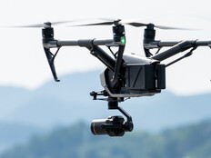
Several years ago, drones began appearing in emergency response situations, conducting surveillance and assessing damage. Today, utilities use drones regularly. Every agency involved in disaster responses may somehow deploy a drone as a primary tool, whether for damage assessment, search and rescue, overall surveillance and more.
During the approach of Hurricane Florence in September, authorities alerted more than one million people and advised them to evacuate their homes. Drones gathered data for damage reports caused by the hurricane, which informed citizens when they might return home, reports Wired.
“Utilities are spelling out where they have vulnerable, infrastructure-like long power lines. The company is also pulling together pre-event data: ‘before’ pictures to contrast with the ‘after,’” according to Wired. “Getting those ‘after’ images is the challenge. No aircraft can fly in the storm itself, and even when it passes, they have to get into place to start work.”
MORE FROM STATETECH: See how counties are using mobile communications centers to respond to emergencies!
Drones Help Restore Power, Ensure Clean Water
Facing Hurricane Florence, Edison Electric Institute, an industry group coordinating utility recovery efforts, tracked the recruitment of at least 53 drone teams to identify and fix damage from the storm. Each team fielded more than one drone and collectively about 100-160 operators flew the drones, according to Fortune.
The drones can assess damage quickly and pinpoint trouble spots in places where it may be dangerous for people to venture. Companies like Duke Energy and Southern Company deployed drones with infrared and high-zoom sensors that can inspect substations, locate malfunctioning solar panels and help to restring power lines, according to Fortune.
When Hurricane Harvey flooded Houston in 2017, CenterPoint Energy assessed a damaged substation and built a backup. To assess damage, the energy company turned to IBM. Drones “can also be used to check hospital generators or alert residents if the local hardware store is open to get supplies,” Chris Behme, an energy and utilities partner at IBM, tells Fortune.
The Long Island branch of the Public Service Enterprise Group has deployed drones to examine substations as well as transmission and distribution systems. John O’Connell, vice president of transmission and distribution operations at PSEG Long Island, tells Unmanned Aerial Online, “Compared to using helicopters or ground-based observation, UAVs give us better data on the electric system, which directly improves system reliability and employee safety.”
The eruption of the Kilauea volcano in Hawaii came with bursts of lava up to 160 feet high, destroying more than 700 homes and forcing the evacuation of more than 2,000 people, reports Reuters.
Drone operators went into “24/7 disaster mode,” surveying the volcanoes with drones and other tools. Data collected by the drones helped to advise scientists as to what the effects of a volcano eruption on the mainland might be.
According to Reuters, “Water and electric utilities wanted to know if the plumes of fine ash would affect water quality, and how they might interfere with transmission lines.” Damage assessments from Hawaii could predict future trends.
Potential Future Benefits of Drone Surveillance in Disasters
In the future, drones will do even more to assist with disaster response and recovery. Curbed reports architect Stephanie Chaltiel recently demonstrated a prototype drone that builds a mud shelter for use in an emergency. Emergency responders can set up lightweight wooden frames and cover them with burlap. The drone then covers the structure in mud, providing occupants with protection from the elements.
Meanwhile, IBM applied for a patent for technology to track drone flights through a blockchain ledger, according to Coingeek.
“The goal, according to the patent application, is to ensure that airspace controllers, regulatory bodies and even UAV owners can check and supervise the rising number of drones in the sky,” the report says.
As major storms become more costly — at $170 billion in damages, Hurricane Florence may be the most expensive storm in U.S. history — innovators will continue to find ways in which relatively inexpensive drones can mitigate potential disasters.
This article is part of StateTech's CITizen blog series. Please join the discussion on Twitter by using the #StateLocalIT hashtag.