Public Safety Agencies Deploy Drones to Plan for and Prevent Disasters

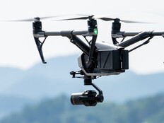
Cities, counties and state governments turn to drones to help fight crime, combat fires and assist in rescue efforts. By 2018, at least 910 U.S. sheriff’s offices, police and fire departments, and emergency services agencies had purchased drones, an 82 percent increase from the previous year, according to a study by the Center for the Study of the Drone at Bard College.
The most common uses of drones are for search and rescue, emergency response, crime scene and accident scene investigations, and tactical situations, where an aerial perspective provides valuable information, says Dan Gettinger, the center’s co-director.
“We are still in the early days of adoption, but there is a growing pace of adoption by public agencies nationwide,” he says.
Yet public safety agencies aren’t just using drones to help fight crime and battle fires. They’re using the technology to prepare for and prevent emergencies.
Drones Can Map Infrastructure and Vegetation
The South Carolina Department of Transportation has partnered with Clemson University researchers to use its DJI Matrice drone to build 3D models of bridges. The goal is to assist with manual bridge inspections by programming drones to autonomously inspect bridges and build 3D models, says Scott Shaffer, SCDOT’s unmanned aerial systems coordinator.
In the future, software will analyze new and previous 3D models of bridges to point out deterioration or safety problems that need to be fixed, says Eric Stuckey, SCDOT’s engineering technology and research manager.
The Los Angeles Fire Department is also using drones for pre-incident missions that create 3D maps of critical infrastructure. That way, if there’s a hostage situation in the future, an incident commander can view an existing 3D map of a college campus or neighborhood to deploy resources and develop escape routes for people, says battalion chief Richard Fields.
“Instead of using Google Earth and relying on radio communications, now you have a multifaceted map that you can use to plan and direct resources very specifically,” he says.
LAFD’s fire prevention bureau is also using drones to map public parcels of land to determine where vegetation should be cleared to protect against fires, Fields says.
“Instead of just taking a surface-level picture with an iPad, now we can take it at a higher level. If you plug that information into software, you can get vegetation density,” he says. “It paints a much clearer picture of what your challenges are.”
For more on how state and local governments are using drones, check out our feature story, “Drones Keep an Eye on People and Property to Aid First Responders.”