Drones Fly in to Aid Public Safety, Offer Disaster Relief

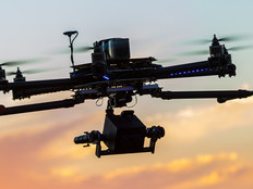
Intel’s drone display put on quite a show at the Olympics this year, but the possibilities of the technology expand beyond decorative Olympic rings and pizza delivery, and into doing public good. In fact, state and local governments across the country are putting these flying marvels to good use, particularly when it comes to public safety and disaster response.
While regulations are still in the works and the technology still has a way to go, innovative governments are starting to test drones in the field with the hopes that they can solve several civic challenges.
SIGN UP: Get more news from the StateTech newsletter in your inbox every two weeks
Public Safety Get a Boost from Eyes in the Sky
At the end of February, Texas’ Department of Public Safety was the latest to announce that it will use the unmanned aerial vehicles in a variety of public safety uses across the state. That includes missions related to “officer safety, search and rescue, disaster support, aerial observation support, crash reconstruction, crime scene photography and communication tower inspections,” according to eParisExtra.
But the department certainly isn’t the first to do so. Drones and law enforcement are becoming fast friends as the technology represents a safe and cost-effective way to view potentially dangerous situations. In fact, a recent report from the Center for the Study of the Drone at Bard College finds that 167 public safety agencies acquired drones for surveillance use in 2016 alone, with law enforcement leading the way. This brings the number of public safety agencies to acquire drones to 347, spread across 43 states.
"Drones provide an opportunity for us in tactical situations to increase public safety and officer safety with regard to their situational awareness," Captain Vern Sallee of the Chula Vista Police Department told StateScoop, speaking on the department’s decision to implement drones for routine patrols. "This is especially true if we're looking for missing persons, going through terrain that is very difficult to access — like a canyon for instance — and it just allows us to cover larger spaces."
Other localities are putting the tech to work in more specific use cases. Louisville, Ky., for example, has applied for a special program run by the Federal Aviation Administration that could grant it the right to pilot drones across the city in order to respond to scenes of possible gun violence.
Already, Louisville has spread gunshot-detecting sensors throughout the city. When a possible shot is detected, officers are deployed to the scene. The new program would send out drones as well, which could allow officers to get eyes on the scene ahead of time, enabling them to know if there was a problem, as well as prepare for what they might encounter.
The program will not only allow law enforcement to get eyes on the scene more quickly, possibly leading to more arrests, but it will also allow the city to get a leg up when it comes to integrating drone use.
“We think drones being integrated into urban environments is something the city needs to be involved with, so by taking the lead on this … program, we feel like we can have a say on how the drone ecosystem in our city develops,” Chris Seidt, Louisville’s director of information technology, tells Government Technology.
Drones Simplify Disaster Response
After Hurricane Harvey, much of Houston was devastated and it was almost impossible to know how to reach those who needed care, or where they were. Enter drone pilots, which came onto the scene on their own accord from various states to help survey roads and damage in places that helicopters can’t reach. The pilots also partnered with local agencies to better understand the needs of municipalities impacted and better convey which routes were available, and which needed coverage.
“We did mapping, damage assessment, thermal imaging," drone pilot Brian Scott told FOX Carolina. "We were giving real-time situational awareness to the commanders on the ground.”
Drones can not only help to offer immediate care to those impacted by a disaster, but can gather and document data that can help cities rebuild after an incident occurs. In the aftermath of Hurricane Harvey, the FAA allowed insurers to use drones to better assess damage.
“As weather conditions stabilize, and we are able to enter those communities that sustained damage, we will have a clearer picture on how best to deploy our claims resources, including our drones,” Tim Murray, head of Inside & National Property Claims for Farmers Insurance, tells Government Technology. The technology helps improve response time and safety for claims officers and can reach and survey areas that are otherwise unreachable because of floods or road damage. Moreover, the drones are equipped with tools that can help generate reports in minutes, which severely cuts the amount of time to file claims and get repairs started on homes.
“We’re using them to really try to start the recovery process for our insurers and help assess their damage and get them where they need to be,” Kristina Tomasetti, strategic innovation director at USAA, told Government Technology. “Which, in times like these, is critical to do this as fast as we can for them.”
Geofences Can Keep Unruly Drones in Bounds
Drones might be emerging as particularly helpful tools for states and local governments, but, as with any technology, they can be misused. In fact, they have a particularly pesky way of wandering into airspace where they aren’t wanted, and that can include everything from stadiums to emergency scenes.
Luckily, technology exists to help stop drones from entering unwanted airspace — although not all drones are equipped. Geofencing, or virtual perimeters based on GPS data, can be set to keep drones out of certain, restricted areas. These virtual fences can be programmed into individual drones and adjusted as necessary.
“Think of it as an invisible dog fence,” Brent Klavon, board member of the Association for Unmanned Vehicle Systems International and director for commercial drones at Aviation Systems Engineering Co. in Jacksonville, Fla., explains to The Florida Times-Union. “If my dog [with an electronic collar] tries to leave the yard, it gets zapped and turns around. Similarly, a drone would know it’s approaching an invisible fence … and it would hit that bumper and return.”
The parameters can be set via a box on the drone or a remote setting. While the technology is still very much emerging, it’s likely that it will be standard for drone operators to incorporate it into the settings in the near future in order to better control unruly drones and keep them out of restricted airspace.
This article is part of StateTech's CITizen blog series. Please join the discussion on Twitter by using the #StateLocalIT hashtag.