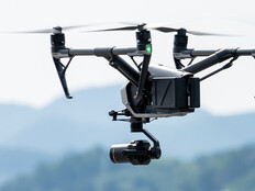

Tracking Drones Through Radio Frequencies and Radar
Markey identified current technologies that agencies can use to detect and track drones. One is radio frequency technology, which can essentially study and track communication to a drone. Authorities can triangulate a drone’s position by reading radio frequencies.
“That’s probably the most cost-effective way today — not a lot of false positives,” Markey says. “And I can tell the type of drone and the serial number in certain scenarios to see if it's a repeat offender.”
There’s also radar technology, which comes with some challenges that require a multilayered approach to work effectively. For example, it’s hard with only radar technology to differentiate between a drone and a bird. However, officials can make that distinction by using cameras and video analytics.
“It’s figuring out how you want to start, traditionally with radio frequency, then maybe adding cameras and then maybe adding radar,” Markey says. “It really is taking a layered approach and developing it over time.”
LEARN ABOUT: How firefighting drones help localities battle blazes in the wild and in cities.
Questions About How to Handle Threats in the U.S.
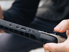
Organizations can use existing technologies to neutralize unmanned aerial systems. Dedrone has its own DroneDefender, a jamming device that essentially forces a drone to return home to its remote control or to safely land. That said, there are still legal questions about who has the authority to stop a drone.
“Today, the way the laws are written, drones are considered aircraft,” Markey says. “So, if I take a shotgun or a jamming gun or something else to take that drone out of the sky, I’m essentially shooting down a 747. That’s a big no-no.”
There are also concerns about collateral damage, as it’s difficult to jam only the frequency being used for communication by a specific drone. With these risks in mind, finding the pilot is the best course of action.
Dedrone’s RF-300 is a radio sensor that automatically locates drones and their pilots through internal digital processing of radio signals.
Looking ahead, Markey sees a future where municipalities partner with Dedrone and other organizations to identify, track and monitor all local drones for more effective unmanned traffic management.
This article is part of StateTech’s CITizen blog series. Please join the discussion on Twitter by using the #StateLocalIT hashtag.